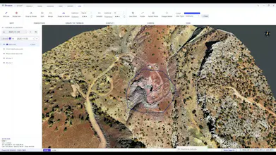
STREAM is a native Windows app for engineers who work with terrain. Survey data got huge — a single site DEM or point cloud can be gigabytes. STREAM streams it out-of-core and renders on the GPU, so it opens instantly and stays responsive. From there you get the deliverables: cut/fill volumes, cross-section cubature with DXF drawings, stockpile tonnage with PDF reports, contours, hydrology, sun & shadow and change detection. Fully offline — your data never leaves your machine.
Hi PH 👋 I'm Mehmet, and I built STREAM.
The problem: survey data got huge. A single site DEM, orthophoto or LiDAR point cloud can be
several gigabytes. Most desktop tools either choke on it or push you to the cloud — and a lot of
engineers simply can't send client data to a server.
STREAM streams that data out-of-core and renders it on the GPU (Vulkan), so a multi-gigabyte
survey opens immediately and stays smooth while you pan and measure.
From there it gives you the deliverables engineers actually hand over:
• Cut/fill volumes against real terrain, a flat design level or another surface
• Cross-section cubature with a station-by-station table and DXF drawings
• Stockpile volume and tonnage with a print-ready PDF report
• Contours, slope/aspect, viewshed, hydrology, sun & shadow
• Change detection between two surveys, with volume ± uncertainty
Everything runs locally — no account needed to process, no upload, works with no internet.
Imports GeoTIFF, LAS/LAZ and DXF; exports DXF, CSV, GeoTIFF and PDF.
It's a free public beta for Windows 10/11 (x64) — all features unlocked, no time limit, no
watermark. The app and site are in 6 languages.
I'd love feedback from surveyors, drone operators, earthworks and mining teams: what's the one
measurement that still eats your time?
Report
No reviews yetBe the first to leave a review for STREAM Terrain Modeling & Analysis