Launching today

Unfenced
Land for sale that actually borders public land
74 followers
Land for sale that actually borders public land
74 followers
Checks ~700,000 U.S. listings every week against official public-land maps and shows the ~13,600 homes and land parcels that actually touch national forest, BLM and state land. Each one is measured from its county parcel boundary: the shared edge in feet, drawn on a map, plus how much public land is behind it, elevation, road access, flood zone and wildfire hazard. Search by ZIP or state. Free, no account needed.


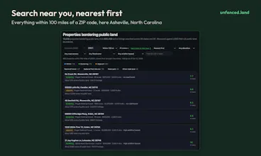


@other_waters Showing the actual shared boundary length is more helpful than just marking two areas next to each other on a map.
@robert_smith52 Thanks Robert! That number is the heart of it. During my search for land, I realized “Near state land” can mean a mile away. Each property page draws the edge on the map too.
@other_waters I'd love a way to save a few parcels and compare them later. Once you're looking at several properties, the details start to blur together.
@ayazakram Great point. Unfenced isn’t a listing site and only updates weekly, so the best place to save favorites is still a Zillow/Redfin type platform, where prices and status are live. Each property here links straight to its listing. Think of Unfenced as the check you run first: does it actually touch public land, how much, and what’s the ground like. If you want new matches as they turn up, the free email alerts save a search for you.
The elevation info caught my eye. Flat land and steep land can look pretty similar on a basic map.
@sukumar_sukumar1 Yes, that’s coming next. A few people asked for the same thing, so I’m building slope from USGS elevation data: how many acres of each parcel are under a 15% grade, how steep the ground is where a road meets it. It will go live later this month.
Europe when? 👀
@busmark_w_nika Ha, I’d love to! The hard part is the listings data, there's no open feed for European property listings like we have in the US. Public land data is surprisingly good in other places like Canada and New Zealand too
Measuring the shared edge from the county parcel boundary is a nice touch. What happens when the parcel layer and the listing don't agree, say after a lot split? Do you still show the listing, or leave it out until the county data catches up?
@xenit_v0 Great question, it happens quite often. County parcel layers can lag a lot split by several months. The listing still shows, measured against the parcel at the listing’s location and the site checks the two against each other. If the listed acreage and the parcel disagree badly, like a 5-acre lot sitting on a 200-acre parent tract, the property gets a note or the acreage is withheld. Congrats on the Spiralens launch too!
This is great. A high/low price option would be more helpful than the single high filter. A view by map option would be great too.
Thanks for this, it’s now part of my home search tool bag!
@doubletough Thanks so much, good luck with the home search! The full map - unfenced.land/map already has a price range high/low and an acreage range. Every state page opens with a map of its properties. You’re right that the list pages only have a maximum price so far. I’ll add a minimum there in the next update.
For anyone who spends weekends outdoors, finding land right next to public land could make a real difference.
@vhim_jana Thanks! That’s exactly who I built this for. I’d be interested to hear what you find.