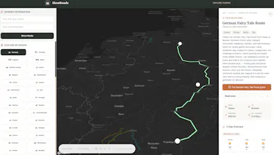
SlowRoads is an interactive map and tour planner curated for slow travel enthusiasts. Discover over 200 of the most beautiful scenic driving routes across Europe. Filter paths by steepness and elevation profiles—perfect for classic campervans or scenic riders. Free to use, no sign-up required, and fully multilingual. I would love the Product Hunt community's feedback. What feature is missing that would make this your go-to road trip planner? How does the map interface feel to you?
No reviews yetBe the first to leave a review for SlowRoads
Maker
📌
I’m thrilled to share SlowRoads with you all today.
I built this platform because I realized that standard navigation apps are optimized for speed, not beauty. When you are traveling in a classic campervan or just want to enjoy the drive, you don't want the fastest highway — you want the best scenery. More importantly, you need to know if your vehicle can actually handle the route!
I mapped out over 200 of the best scenic driving routes across Europe, but wanted to go beyond just plotting lines on a map.
Here is what makes SlowRoads different:
Elevation & Steepness Profiles: Crucial for slow travelers. You can filter routes so you know exactly what your van is getting into before you start climbing.
Interactive Planning: A custom map interface that lets you view routes, check local weather, and plan your itinerary visually.
Multilingual Support: Fully accessible in multiple languages to support travelers across Europe.
Report
The elevation filter is a really thoughtful touch, especially for campervan trips where steep passes can be a dealbreaker. The map felt clean and quick on my laptop, though I'd love to see weather overlays for each route.
Report
Maker
@grkem154790 Hi Görkem, thanks for the feedback. Regarding the weather: we want to keep our interactive map as clean and fast as possible, so we avoid loading heavy radar overlays (Windy already does this perfectly!).
However, we do display live weather! If you open any route page, we fetch a live 3-day forecast (via Open-Meteo) for the start and end coordinates of the route so you can quickly scan for clear skies, rain, or low temperatures before you set off..."
Report
The elevation profile filter is genuinely clever, especially seeing it surface routes that actually work for heavier vans instead of just suggesting impractical scenic roads. Clean execution overall.
The elevation filter is a really thoughtful touch, especially for campervan trips where steep passes can be a dealbreaker. The map felt clean and quick on my laptop, though I'd love to see weather overlays for each route.
@grkem154790 Hi Görkem, thanks for the feedback. Regarding the weather: we want to keep our interactive map as clean and fast as possible, so we avoid loading heavy radar overlays (Windy already does this perfectly!).
However, we do display live weather! If you open any route page, we fetch a live 3-day forecast (via Open-Meteo) for the start and end coordinates of the route so you can quickly scan for clear skies, rain, or low temperatures before you set off..."
The elevation profile filter is genuinely clever, especially seeing it surface routes that actually work for heavier vans instead of just suggesting impractical scenic roads. Clean execution overall.