
Quetzly
Test, monitor, and visualize your location APIs in one place
51 followers
Test, monitor, and visualize your location APIs in one place
51 followers
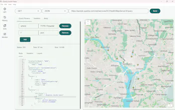
Quetzly helps developers, GIS and IT teams test, monitor, and visualize geospatial APIs. Send http requests, adjust headers and query params, and inspect JSON with an integrated editor. Render WMS, WFS, GeoJSON and ArcGIS services on an interactive map, toggle layers, zoom to extents, and export data as GeoJSON or Shapefile. Track endpoint health to reduce downtime and keep location services reliable. Quetzly is currently in open Beta. Try it for free.


Quetzly
The focus on location APIs specifically is smart - those are notoriously hard to debug when things go wrong (coordinates that look valid but aren't, geocoding edge cases, etc.).
Curious how you handle visualizing failed requests vs successful ones? We've found that seeing the actual request/response payloads is often more useful than just status codes when debugging API issues.
Congrats on the launch!
Quetzly
@kxbnb thanks! Good point. We check for schema validation at the moment. Whether it's valid Geojson or esri json. If not, it doesn't get visualized on the map and the user still gets json response but with a warning. Next step for me is to add some more specific validations like highlighting flipped coordinates and malformed geometry. This is great feedback!
Congrats on the launch! Love how Quetzly unifies testing, monitoring, and live map visualization for WMS/WFS/GeoJSON into one workflow for geospatial teams.
Quetzly
@zeiki_yu thank you!