
OverCity: Flight Location
See cities below your flight
2 followers
See cities below your flight
2 followers
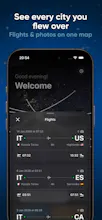
Ever looked out of a plane window and asked, "What city is that?" OverCity gives you the answer instantly, even without internet. Using your flight's position and advanced offline maps, OverCity shows the exact city, town, or landmark beneath your aircraft in real time. Perfect for curious travelers, aviation lovers, and window-seat explorers. Capture the moment with location-aware photos, automatically tagged with the city you were flying over a unique way to remember every journey.


Hey Product Hunt 👋
Ever been on a flight, staring out the window, wondering “What city is that?” That question is exactly why we built OverCity.
OverCity tells you what’s directly beneath your plane in real time, even without internet. Using your flight’s position and advanced offline maps, it shows the exact city, town, or landmark you’re flying over — at cruising altitude.
✈️ Why we built it
- Plane windows are magical, but the context is missing
- In-flight Wi-Fi is unreliable (or expensive)
- We wanted a privacy-first, offline way to turn flights into memories
📍 What it does
- Real-time city detection while flying
- Works 100% offline
- Accurate at altitude
- Take photos automatically tagged with the city & country below
- Lightweight and battery-friendly
📸 The magic
Every photo becomes a story:
- “This was taken over Cairo.”
- “This was above the Alps.”
No guessing. No searching later.
🔒 Privacy-first by design
- No account
- No tracking
- Everything happens on your device
If you love flying, maps, or window seats, we’d love for you to try OverCity on your next flight.
Happy to answer questions and would really appreciate your feedback! 🚀