
Assetfy
Flurstücke, Bodenrichtwerte, Bebauungspläne, & ALKIS-Monitor
2 followers
Flurstücke, Bodenrichtwerte, Bebauungspläne, & ALKIS-Monitor
2 followers
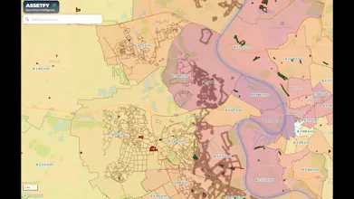
“Assetfy combines cadastral maps, land value indicators, zoning plans, heatmaps, and AI‑driven analysis on a single map. Locations are evaluated instantly, opportunities are recognized immediately—based on solid, data‑driven analysis.”


Assetfy originally grew out of a passion for identifying the potential of niche real estate through the smart combination of geospatial data. That is how I came across my garden waterfront property on the outskirts of Berlin, located in an undeveloped outer area, which now includes four boat moorings.
The odyssey that followed exposed a structural problem: unclear boundaries, fragmented cadastral data, and a lack of transparency across state lines. Years later, the economic relevance became very tangible when a neighboring investor realized that my property was the very one blocking water access to 6,500 sqm of building land. The separate cadastral and parcel data services of Berlin and Brandenburg are a perfect example of this fragmentation.
And that is how Assetfy gradually emerged, driven by intrinsic motivation, as my geo-real-estate intelligence platform: rethinking acquisition and analysis. Data-driven, nationwide, and all on one seamless map.