
Dispersed
Explore your public land
91 followers
Explore your public land
91 followers
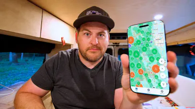
Finding quality camping on public lands shouldn't require hours of research. Dispersed makes it simple with comprehensive USFS, BLM, and NPS campground data, community reviews, GPS coordinates, and premium Hidden Gems from real campers.


Dispersed
Hey Product Hunt! I'm excited to share Dispersed with you today.
THE PROBLEM
I run a camping YouTube channel exploring public lands across America. I was spending $40-60/night at campgrounds when thousands of free spots existed on USFS and BLM lands - but finding them was a nightmare. Hours jumping between government websites, outdated forums, and incomplete apps.
I'd show up to find "No Camping" signs or closed roads. There had to be a better way.
THE SOLUTION
As a developer, I built Dispersed - pulling data directly from USFS, BLM, and National Park Service sources to create the most complete public lands camping database available.
WHAT MAKES IT DIFFERENT
Official Sites Free Forever: All official sites and campgrounds from government sources are free forever, period.
Data-Centric: Official geodatabase sources, not crowdsourced guesses. Most apps miss 70-80% of campgrounds.
Validated Public Land: Every site verified on confirmed public land using official land boundary sources and spatial analysis. No accidental trespassing.
Verified Submissions: We verify every user submission. Submitted campsites are a premium only feature, so everyone has skin in the game to keep the quality high.
Better UX: Built mobile-first for field conditions. Offline maps, satellite imagery, works without cell service.
Real Reviews: Community Check Ins with photos from actual campers.
LAUNCH SPECIAL
Submit 5 qualified campsites: FREE Premium for a year!
Built for budget campers, van lifers, weekend warriors, overlanders and anyone who believes outdoor adventures shouldn't cost a fortune.
Would love your feedback and questions!
Congratulations @wilderadventures! 🎉 The public land boundary verification on Dispersed is impressive, especially how every site is verified on confirmed public land using official sources—eliminating that "accidental trespassing" anxiety is huge. Curious—what inspired you to pull from 25+ official geodatabases versus going the crowdsourced route? The offline maps with satellite imagery are perfect for field conditions. Wishing you tons of engagement and feedback today!
Dispersed
@kjosephabraham The existing apps in this space are all purely crowdsourced, and from my own experience traveling long term there are many official spots missing from those apps, leaving you bouncing back and forth between the app, google maps, and the USFS/BLM campground search form (which is awful to use). I wanted to start with the official exhaustive data first, so at the very least we could provide users with the option of full coverage between our app and an existing crowdsourced app.
That said, the existing crowdsourced apps have terrible UX and allow anyone to submit whether its legal or not, on public land or not, etc. So I think that area is ripe for disruption, which is why we offer user submitted Hidden Gems as a premium feature. Think of it like a member's club where everyone that submits has skin in the game to keep the quality high, and that affords us to be able to moderate it heavily.
Dispersed
@adamcbuchanan It's available to download in Canada, however we don't have any public camping info on Canada yet. I've got Crown land on my to-do list. Users are allowed to submit sites in Canada though!
RewriteBar
Really well thought out! I love the focus on verified data sources and offline access. How hard was it to pull consistent data from the different agencies?
Dispersed
@m91michel Thank you! I'd say sourcing and processing the data was a 50/50 split of effort vs building the entire app. I spent a couple of months just going through different data sources and writing scripts to load them all up and stage my initial dataset in a QGIS project long before loading it into the application database. I'm currently doing the same thing digitizing MVUM maps for the next major premium feature, which is an even more involved data collection project (extracting data from hand build PDFs on a ranger district by ranger district basis, about 600 in total across the US).
In all the current database was sourced from about 25 different datasets that I had to reconcile and deduplicate to get as much coverage as possible. Still some states don't have much descriptive info except for a name and coordinates. I intend to source better info from user reviews and check-ins in the future.
RewriteBar
@wilderadventures Wow! This sound like a lot of work. Are you also planning to tackle european maps after the US ones?
Dispersed
@m91michel Canada first, then Europe!
Very interesting idea. We’re also working on a project at the intersection of AI and tourism, which will also feature maps. We’ll be launching in a few weeks.