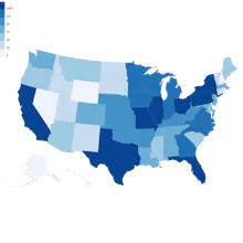
An easy to use tool that allows you to upload spreadsheets full of zip codes to create nice looking thematic maps that can visualize the density of things like sales, deliveries and real estate across US states and counties.
Hey everyone, I would like to introduce my mini SaaS product - Zipcodeheatmap. It does one thing well, and that is to generate heat maps of US states and counties from zip codes stored in spreadsheets.
There is no limit imposed on the number of zip codes that can be processed in a single spreadsheet upload and once your heat map has been created you can export it as an image or generate a PDF or CSV report of the aggregated data by state or county.
Zipcodeheatmap is useful for anyone who works in sales, marketing, real estate, logistics and more.
You can try out Zipcodeheatmap for free to get an idea of what your heat map will look like. Any feedback or suggestions are welcome!
Report
randomly found this while scrolling, not sure how practical this is, feels like a very niche use case, really need more global coverage for it to be useful, do u have any plans to expand beyond the US, adding European countries could be interesting
Cool, super useful if embedded in web apps; makes a developers life much easier. We just launched our user feedback tool on Product Hunt today as well (Lancey), we aggregate user feedback, and I could totally see how a heatmap of which regions are over or underrepresented in feedback being useful.
Hey @james_david_101 this is very helpful. Would be great to see if you could add some additional countries especially in Europe like UK, Germany, Spain or Italy. This would go great on listing pages to show the density of venues in certain areas.
Congrats on the launch 🚀
Hey James, this is such a useful tool, really like how user-friendly it is, any plans to expand this to other countries like the UK, Germany or Spain as you said, have you seen how tools like Mapbox or Google Maps handle heat maps, they might give you some interesting ideas.
Report
I think having the option to export maps as high _ resolution images is super useful.
Zipcode Heat Map
Lancey
YourGPT
Mailfox
Zipcode Heat Map
Mailfox
Zipcode Heat Map