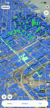
Trailshed gives hikers, commuters, and roof climbers an instant idea of what their views look like from any location. Freely drag your marker around to get an instant viewshed of a location, or have it follow your own upload GPX trail file to see the prime views on your next hike. Optionally toggle buildings to see how they impact your view, and even draw new buildings to see if new developments change your view of certain landmarks! Available on our website and the App Store.
When I was in college, I had the (questionable) hobby of climbing the roofs of buildings on campus. My favorite part was getting to the top and seeing the view of the whole city in front of me. The sense of wonder I got when I experienced a view that was off limits and hard to get to was incredibly special.
While I haven't snuck onto any roofs in a while, I always like to imagine what the view would be like from anywhere I haven't been, whether it's a house I'm about to move in to, a random street corner, or the top of a mountain after a multi day long backpacking trip.
This is why I made Trailshed. Trailshed allows you to quickly and easily see what your viewshed would be like at any location on Earth. My friends and I have used it to see if parts of lake Tahoe would be visible from certain ski slopes, see if buildings would obstruct our view, and find quiet romantic spots with great views of the skyline. Hope you can also use it find a place with a great view!
Report
Curious how fresh the elevation and building data is, especially for off-the-beaten-path trails. Are you pulling from live satellite sources or is it refreshed on a set schedule?
Report
Maker
@birglvhsv We query our elevation data from terrarium, which is mostly static. Our building data is queried from Overture, which updates their data monthly.
Off the beaten path trails should still have accurate elevation maps!
Report
How current is the terrain and building data, especially for less popular hiking regions outside the US, and does the viewshed account for tree canopy or just the bare ground elevation?
Report
Maker
@alperenkerepmm We don't account for tree canopy obstructions yet, but that feature is next on our list! Our Terrarium dataset we used is mostly static, and out building data from Overture is updated monthly.
Report
Dragging the marker around and watching the viewshed update in real time feels incredibly responsive, the kind of instant feedback that makes you actually want to explore the map instead of just getting an answer.
Report
Maker
@brahawj Thanks - Spent a lot of time optimizing that, glad it was noticed!
Report
Dragged the marker around my neighborhood and the toggle for buildings was surprisingly accurate, even caught the new construction blocking my favorite sunset spot.
Report
Dragging the marker around my neighborhood was surprisingly fun, and seeing how new buildings block the sunset view made me think twice about a planned addition. Solid tool.
Report
Loading up my usual weekend loop and watching the viewshed reveal those hidden ridge viewpoints was genuinely satisfying, the buildings toggle is a nice touch for city walks too.
Report
No reviews yetBe the first to leave a review for TrailShed
Curious how fresh the elevation and building data is, especially for off-the-beaten-path trails. Are you pulling from live satellite sources or is it refreshed on a set schedule?
@birglvhsv We query our elevation data from terrarium, which is mostly static. Our building data is queried from Overture, which updates their data monthly.
Off the beaten path trails should still have accurate elevation maps!
How current is the terrain and building data, especially for less popular hiking regions outside the US, and does the viewshed account for tree canopy or just the bare ground elevation?
@alperenkerepmm We don't account for tree canopy obstructions yet, but that feature is next on our list! Our Terrarium dataset we used is mostly static, and out building data from Overture is updated monthly.
Dragging the marker around and watching the viewshed update in real time feels incredibly responsive, the kind of instant feedback that makes you actually want to explore the map instead of just getting an answer.
@brahawj Thanks - Spent a lot of time optimizing that, glad it was noticed!
Dragged the marker around my neighborhood and the toggle for buildings was surprisingly accurate, even caught the new construction blocking my favorite sunset spot.
Dragging the marker around my neighborhood was surprisingly fun, and seeing how new buildings block the sunset view made me think twice about a planned addition. Solid tool.
Loading up my usual weekend loop and watching the viewshed reveal those hidden ridge viewpoints was genuinely satisfying, the buildings toggle is a nice touch for city walks too.