Launching today

Tatry Planer
Darmowy planer szlaków w polskich i słowackich Tatrach
2 followers
Darmowy planer szlaków w polskich i słowackich Tatrach
2 followers
Darmowy planer szlaków w Tatrach. Działa także bez zasięgu.




Launch Team

ArticosTest your messaging on your audience, right inside Claude or ChatGPT
Promoted
Hi Product Hunt 👋
I’m Stanisław, and I built Tatry Planer after hours over the past year.
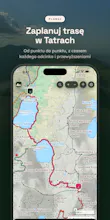
The Tatras are a small mountain range on the Polish–Slovak border, and one of the busiest in Europe. Planning a hike there usually means checking four places: a map for the route, the national parks for trail closures, the weather for afternoon storms, and a guidebook for realistic times. I wanted all of that on one screen.
What it does:
treats both sides of the border as one trail network (about 1,100 km of marked trails, 145 described routes),
calculates walking times with a model calibrated against signposts and guidebooks, not generic map speeds,
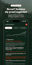
shows current trail closures from both national parks and the storm risk for your hike,
works offline on the trail, with turn-by-turn guidance and an audio guide,
has a 3D summit view built from lidar terrain data.
It’s free, with no ads, no account and no subscription. One honest caveat: the interface is in Polish for now. I’d love to know whether an English version would make you plan a trip to the Tatras.
Happy to answer anything about the app or how it’s built.