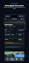
You've got the trail picked. But is the avalanche danger creeping up? Is there smoke? Is the river too high to cross? Will your phone go dark for 6 miles? Strata answers all of it in one look - so you spend your morning hiking, not doomscrolling forecasts. ποΈ
No reviews yetBe the first to leave a review for Strata
Maker
π
Hey Product Hunt π
Every hiker knows the pre-trip ritual: eleven browser tabs, three forecasts that disagree, a fire map from 2019, and a gut feeling. Then you drive two hours to the trailhead and find out the road's washed out.
Strata is the app I wanted for that morning. You pick a route, and it gives you one honest read on whether today's a good day to go:
π¨οΈ Avalanche - the danger rose for your exact aspects and elevation
π₯ Wildfire & smoke - active perimeters and air quality, not last season's map
π River flow - is that crossing a step or a swim?
βοΈ Weather + sun timing - including "when does it actually get dark on you"
π΅ Cell dead zones - see exactly where you'll lose signal before you're out of it
β¨ An a safety brief for the route, so you're not interpreting six dashboards yourself
Plus the stuff that makes a planner actually usable: offline maps, slope & aspect overlays, public-lands boundaries, a snap-to-trail route builder, 500+ curated backcountry routes, and condition alerts that ping you if your saved trail's forecast turns while you're planning.
Coverage is nationwide. Curated routes run coast to coast - Sierra, Cascades, and Rockies through the Appalachians and the White Mountains - on trail data for the entire Lower 48. Slope/aspect overlays cover every major range West and East; public-lands boundaries go national, Alaska included. πΊπΈ
Who it's for: day hikers, backpackers, peak-baggers, and ski-tourers - anyone who's ever wished the mountain came with a "check engine" light. π₯Ύ
Free to browse and plan. Pro ($59.99/yr - no monthly, no gimmicky trial) unlocks offline maps, the overlays, the safety analysis, and alerts. If it's not for you, there's a 7-day money-back guarantee, honored personally.
Drop your home trail in the comments - anywhere in the Lower 48 - and I'll tell you what Strata already knows about it. π
Dig in before you head out. β°οΈ
Report
How does Strata pull in the data for things like river levels or smoke reports in backcountry areas - is it piecing together from public sources or do you have your own sensor network?
Report
Maker
@adembezenj9tdΒ No secret sensor network. Strata just fuses a bunch of authoritative data feeds - stream gauges, air-quality models, fire perimeters, weather, avalanche bulletins, etc. - and matches them to your route.
The trick is stitching all of them together and being honest about gaps: no gauge near your trail? We say "no data," not a made-up river level.
Report
The at-a-glance layout for layering weather, fire, and river data feels like it was built by people who actually get cold at trailhead. Skipping the rabbit hole of checking seven different sites before a sunrise start is genuinely huge.
How does Strata pull in the data for things like river levels or smoke reports in backcountry areas - is it piecing together from public sources or do you have your own sensor network?
@adembezenj9tdΒ No secret sensor network. Strata just fuses a bunch of authoritative data feeds - stream gauges, air-quality models, fire perimeters, weather, avalanche bulletins, etc. - and matches them to your route.
The trick is stitching all of them together and being honest about gaps: no gauge near your trail? We say "no data," not a made-up river level.
The at-a-glance layout for layering weather, fire, and river data feels like it was built by people who actually get cold at trailhead. Skipping the rabbit hole of checking seven different sites before a sunrise start is genuinely huge.