
Skyway.run
Navigate the Minneapolis Skyway System
5 followers
Navigate the Minneapolis Skyway System
5 followers
An indoor navigation app to explore the Minneapolis Skyway System, find lunch spots and get directions. Skyway.run keeps you indoors, avoiding -40° weather, and even routes you differently based on building hours.
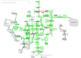


Indoor navigation has generally been limited to airports and certain shopping malls. It requires building owners to maintain their map and directory solo. Minneapolis downtown is like one giant shopping mall--hundreds of buildings connected by second floor bridges and underground tunnels.
My intention with Skyway.run is to create a great indoor walking experience for long distances, like the Minneapolis Skyways. This is the first app that lets you search local businesses, check skyway hours, improve the mapping data, and find turn-by-turn directions that keeps you indoors.
Some of my favorite features:
Skyway Hours: I’ve been locked out of my normal route on holidays like MLK Day or Memorial Day (the coldest days of last winter). Now I can plan my alternate route when I need.
Edit in OpenStreetMap: Lots of other static maps fade away after a few months, because businesses are always opening and closing. I sync weekly with OSM and offer quick ways to open an editor to fix outdated info.
Directions by Hour: Processing on-the-fly routing requests to honor what is open and closed really helps you feel confident you won’t get stuck at a dead-end.
I also open-sourced parts of this app:
https://github.com/HankieCodes/aws-lambda-layer-osmtools