No reviews yetBe the first to leave a review for Pozyx online GeoTIFF viewer
Fin Startups get Fin free for a year + 93% off Intercom
Promoted
Maker
📌
👋 Hi everyone!
I’m part of the team at Pozyx, where we build advanced indoor and outdoor positioning systems for industry. While working on our mapping tools, we noticed how surprisingly hard it was to just preview a GeoTIFF online.
Most tools require you to install heavy GIS software like QGIS, which is great but overkill if you just want to quickly check a file, confirm the georeferencing, or share it with a colleague.
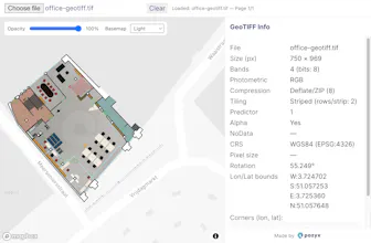
So we built this free, lightweight online GeoTIFF viewer that works entirely in your browser. No signup, no data uploaded, just drag, drop, and see your image instantly appear on a world map.
What makes it unique is the simplicity and quality of the rendering. Even large files look sharp, and you can switch between base maps like satellite, street, and terrain. We also added support for RGB + alpha layers and multiple projections.
Making this tool helped us learn a lot about the geoTIFF format as well. And we're happy we could leverage some existing libraries as well.
Would love to hear your thoughts, it's not perfect yet so we appreciate any feedback.