
OrbitMap
Live 3D map of 15,000+ satellites orbiting Earth
11 followers
Live 3D map of 15,000+ satellites orbiting Earth
11 followers
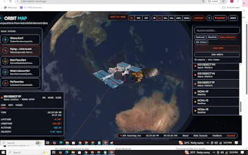
OrbitMap.space is a live interactive 3D map that lets you explore over 15,000 satellites orbiting Earth in real-time. Watch satellites move, get pass notifications, and even "fly along" with them. A fun and educational way to experience the growing orbital ecosystem around our planet. Currently adding a space blog and product recommendations (telescopes, books & more). Made for space enthusiasts, students, and curious minds.


Love how clean the fly-along feature feels, it really puts you in the orbit. One thing that would take this further for me is showing the actual country or operator that owns each satellite when you click on it, plus a tiny flag on the icon. Helps connect the dots between what you see up there and the real-world activity driving it.
@sadkkuakljkm This pairs really well with a similar suggestion someone else made about color-coding by country! Owner/operator info + a flag on click sounds like the perfect way to do it without cluttering the map. Adding both to the roadmap, thanks for the detailed feedback!
love how smooth the orbit trajectories animate when you zoom in, the fly-along feature feels really well thought out for something this data-heavy
@sebahattinuihr Thanks! Getting the trajectory animation smooth while still being accurate to real orbital data took a lot of tuning, so this means a lot
I would love to see a simple toggle to color-code satellites by their launch year or country of origin, so I can quickly spot which nations are most active in orbit right now.
@recep7qkz This is a great idea — would you want both toggles (year AND country), or is one more useful to you than the other? Trying to figure out what to prioritize first.
Honestly kind of mesmerizing watching all the satellites drift by in real time, especially the Starlink clusters. The fly along feature is a really nice touch, feels like you're actually up there with them.
@sabrihacar Really glad it landed well! The Starlink clusters were actually one of the trickiest parts to get smooth — happy that shows 😄
Spent a few minutes clicking around and honestly got a bit lost watching the constellations of satellites drift over my city, the fly along feature is a really neat touch.
@asmin467991 That's exactly the reaction I was hoping for! Which city were you watching over? Curious if certain regions have denser traffic overhead