Launched this week
OpenSlope

OpenSlope

Offline topo ski maps & live friend locator on iPhone

3 followers

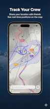
You arrive at a new resort, it’s dumping snow, visibility is… questionable, and everyone in your group swears they “know the way.” OpenSlope is the friend who actually does. Open it up and you get ski maps that feel alive—satellite detail with topo lines so you can read the mountain. You can check elevation profiles and slope insights. Once the map is loaded, it’s yours. OpenSlope keeps going offline. Share a simple code, and your friends pop onto the map as colorful markers.
OpenSlope gallery image
Free
Launch tags:MapsGPSSnow sports
Launch Team / Built With
Threedium
Threedium
Image or Text to 3D Model
Promoted

What do you think? …

Pablo
Maker
📌
I built OpenSlope because I wanted the simplest possible ski map that just works. No accounts, no logins, no setup—open the app, see exactly where you are on the resort map (even with no signal), and orient yourself without fighting with those giant paper maps that never fold back the same way. The second part was my friends: we always split up, and group chats turn into “where are you?” spam. I wanted an easy, low-friction way to share location with a small crew—just a code, see each other on the map, done. During the launch, my process evolved from “cool map viewer” to “ski-day companion.” I kept removing anything that felt like friction, doubled down on offline-first, improved background updates + battery use, and added privacy touches like expiring locations. The goal stayed the same: fewer taps, more skiing.