
Off-Nadir Delta: WebGIS for Sat Data
Browser-Based Satellite Imagery Analysis Platform
4 followers
Browser-Based Satellite Imagery Analysis Platform
4 followers
The simplest way to explore satellite imagery. Off-Nadir Delta is a web-based platform that lets you access satellite data without any GIS software. Search Sentinel-1 (Radar) and Sentinel-2 (Optical) scenes in seconds. See the Earth as natural photos, highlight vegetation health, or see through clouds with radar—one click each. Compare images over time to spot changes in construction, agriculture, or land use. Built for curious minds who want to explore our planet without heavy tools.


Hey everyone! 👋
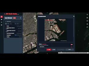
I built Off-Nadir Delta because I was frustrated with the traditional satellite data workflow: install heavy GIS software, configure complex settings, download massive files, just to preview a single scene.
Professional tools are powerful, but they're overkill when you just want to quickly check "what did this area look like last month?"
So I made Off-Nadir Delta – a lightweight WebGIS that lets you access Sentinel-1 (SAR) and Sentinel-2 (optical) satellite imagery directly in your browser. Search by location and date, preview scenes instantly, and compare changes over time. No installation, no downloads, no hassle.
Satellite imagery can reveal activity before it hits the news – construction progress, port traffic, agricultural conditions, and more.
It's the tool I wished existed when I first started working with satellite data.
Give it a try – search for your hometown or a place you're curious about! 🌍
Would love to hear:
What's the first place you looked up?
What would you use satellite imagery for?
What place would you love to see from space?