MapGO

MapGO

Geospatial Intelligence

13 followers

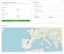
Transform coordinates into actionable insights with MapGo. Calculate distances, resolve administrative divisions, and analyze spatial relationships - all in real-time. Simplify your geolocation tasks with precision and ease.
MapGO gallery image
MapGO gallery image
MapGO gallery image
MapGO gallery image
Free Options
Launch tags:APITravelDeveloper Tools
Launch Team
Anima - Vibe Coding for Product Teams
Build websites and apps with AI that understands design.
Promoted

What do you think? …

Sebastian
Maker
📌
MapGo - Geolocation Made Simple What is MapGo? MapGo is a powerful geolocation tool that helps you identify administrative regions, calculate distances to borders, and find the nearest coastline—all with just a few clicks. Perfect for developers, travelers, and geography enthusiasts, MapGo simplifies complex geolocation tasks into an intuitive experience. Key Features: 📍 Identify administrative regions for any location 📏 Calculate distances to borders and coastlines 🌍 Straight-line (as-the-crow-flies) measurements 🗺️ Interactive map views for easy visualization 🚀 Fast, accurate, and user-friendly Who is it for? 👩‍💻 Developers integrating geolocation features 🧳 Travelers planning routes and exploring new areas 🔬 Researchers analyzing geographic data 🌎 Anyone who loves exploring the world with precision Pricing: Free and lifetime plans available. Start mapping today!
Marc Lou
Congrats on the launch Sebastian!
Sebastian
@marclou Thank you, Marc! I really appreciate your support. It means a lot to me! 😊
Andy Bryn
Worked with Seb on previous projects, fully committed to solving problems for people. has an ability to understand issues and give you something thats actually useful without any bs.
Sebastian
@andy_bryn Thanks, Andy! Appreciate the support and kind words. Cheers!