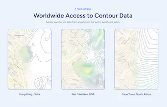
DownloadContourLines.com is built for architects, landscape architects, and 3D designers. Select any area up to 100km² and instantly download 3D contour data in DXF, STL, OBJ, or PDF formats. Save time and get professional-grade data with just a few clicks.
As a student architect, I’ve always struggled with finding accurate contour lines for my projects. Most tools are either way too complicated or take forever to figure out, and dealing with GIS software can be a nightmare. It’s frustrating when you just need something quick and reliable, especially on a deadline.
That’s why I made DownloadContourLines.com. The process couldn’t be simpler: you select the area you need (up to 100km²) using our easy-to-use map, and within minutes, you receive a download link with all the contour data.
Here’s what I love about it:
- Area selection up to 100km²
- Contour intervals of 0.5m, 2m, 5m, or 10m
- Instant download in multiple formats: DXF (for 3D), STL, OBJ (for 3D surfaces), and PDF
- Fast delivery—get your data within minutes
- No need for complex GIS tools—intuitive interface
- Affordable—just the price of a cup of coffee!
For someone like me, who isn't a fan of overly complex software, this tool saves so much time and hassle. You get exactly what you need, quickly and affordably, with professional-grade contour data that integrates smoothly into your design workflow.
If you’re an architect, landscape architect, or 3D modeler and you’ve faced the same frustrations, I highly recommend giving it a try. It’s a simple, reliable solution for getting contour lines without the headaches!
Report
No reviews yetBe the first to leave a review for DownloadContourLines
KickRender