Launching today

City Compare
Drag any city's true-size outline across Google Maps
1 follower
Drag any city's true-size outline across Google Maps
1 follower
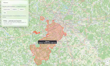
A free browser extension that puts a city's real outline (from OpenStreetMap) on Google Maps and lets you drag it anywhere. It keeps its true size: the outline grows towards the poles and shrinks towards the equator, exactly as Mercator distorts areas. See area, population and density, rotate the shape, or draw your own area with a lasso. Moscow is 25x Paris; Berlin fits Paris 8.5 times. Nothing is tracked, no account. Firefox now, Chrome Web Store soon. Great for geography lessons.


Free
Launch Team

CloudflareStill paying to deploy your apps? Try Cloudflare Workers for free
Promoted
Hi Product Hunt! I'm Egor. City Compare started from one question: how big is Moscow really, next to the cities I know? On Google Maps that's impossible to see, because Mercator stretches everything near the poles.
So the extension stores each vertex of a city's OSM outline as a distance and bearing from its centre and rebuilds it around wherever you drop it (the great-circle destination-point formula). Drawn in Web Mercator, the shape then grows and shrinks exactly as real areas do. It reads the map view from the Google Maps URL, so it needs no access to the map itself.
Which city pair surprised you most? I'd also love feedback from teachers using it for the Mercator lesson.