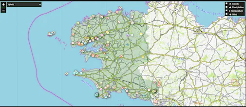
WildTracks is an interactive map with locations of animal habitats, fishing spots, mushroom and berry grounds. We combine data from multiple sources, including user observations, so you can find the best places for the right season and weather conditions.
Why we built this:
I'm an outdoor enthusiast myself. I got tired of scrolling through countless forums and outdated blogs to find relevant info about fishing spots or mushroom grounds. I wanted a single, visual, and up-to-date source for all nature lovers.
What's unique:
Unlike static maps, WildTracks combines data from multiple sources AND relies on user observations. This means you can see not just locations, but also their current activity based on season and recent reports. It's a live, community-driven map.
What I'm most proud of:
Creating a tool that truly helps people connect with nature more effectively. The most rewarding feedback is when a user tells me they found a great spot thanks to the map. We're just getting started, and I'm excited to build this together with the community.
Report
💎 Pixel perfection
This looks amazing! Does the map show real-time data on mushroom seasons, or is it based on historical patterns? I'm planning a foraging trip next month and this could be incredibly helpful!
Thank you for the great question! This is exactly the kind of challenge we're solving.
Currently, WildTracks uses a smart combination of both:
Historical Patterns & Scientific Data: We analyze years of seasonal data, soil types, and forest composition to predict high-probability zones.
Real-Time User Observations: Our community updates the map with recent finds and conditions, adding a live layer of information.
Weather Integration: We factor in recent rainfall and temperature, which are crucial for mushroom growth.
So for your trip next month, the map will show you areas with the highest historical potential, enriched by the most recent reports from other foragers.
What region are you planning to forage in? Knowing that would help me give you a more specific example!
Report
Maker
"Hi everyone! Founder of WildTracks here.
We built this map to help outdoor enthusiasts find the best fishing spots, mushroom grounds, and animal habitats based on real-time data and user observations.
Would love to hear:
- What features would be most useful for your outdoor activities?
- Any specific regions you'd like us to cover?
Ask me anything! 🗺️🎣"
Report
💎 Pixel perfection
This is exactly what our hunting group needs! Are you developing a mobile app? We often have poor internet connection in remote areas, so offline maps would be a game-changer.
Report
This is exactly what our hunting group needs! Are you developing a mobile app? We often have poor internet connection in remote areas, so offline maps would be a game-changer.
Report
Maker
@ericcire This is fantastic feedback, thank you! You've nailed the number one feature on our roadmap.
Yes, a mobile app with full offline functionality is our top priority. We know that a map is useless without a signal, and we're building it to be your reliable guide deep in the wilderness.
We're aiming to have the first version ready by [укажите примерный квартал, например, Q1 2025]. It will allow you to download detailed maps of your target area for complete offline use.
Can I ask a quick favor? Since you're in a hunting group, what specific areas or regions would you want to see covered first in the offline mode? Your input will help us prioritize!
Report
No reviews yetBe the first to leave a review for WildTracks Map


This looks amazing! Does the map show real-time data on mushroom seasons, or is it based on historical patterns? I'm planning a foraging trip next month and this could be incredibly helpful!
@new_user___294202568137ca5c6731f88
Thank you for the great question! This is exactly the kind of challenge we're solving.
Currently, WildTracks uses a smart combination of both:
Historical Patterns & Scientific Data: We analyze years of seasonal data, soil types, and forest composition to predict high-probability zones.
Real-Time User Observations: Our community updates the map with recent finds and conditions, adding a live layer of information.
Weather Integration: We factor in recent rainfall and temperature, which are crucial for mushroom growth.
So for your trip next month, the map will show you areas with the highest historical potential, enriched by the most recent reports from other foragers.
What region are you planning to forage in? Knowing that would help me give you a more specific example!
"Hi everyone! Founder of WildTracks here.
We built this map to help outdoor enthusiasts find the best fishing spots, mushroom grounds, and animal habitats based on real-time data and user observations.
Would love to hear:
- What features would be most useful for your outdoor activities?
- Any specific regions you'd like us to cover?
Ask me anything! 🗺️🎣"
This is exactly what our hunting group needs! Are you developing a mobile app? We often have poor internet connection in remote areas, so offline maps would be a game-changer.
This is exactly what our hunting group needs! Are you developing a mobile app? We often have poor internet connection in remote areas, so offline maps would be a game-changer.
@ericcire This is fantastic feedback, thank you! You've nailed the number one feature on our roadmap.
Yes, a mobile app with full offline functionality is our top priority. We know that a map is useless without a signal, and we're building it to be your reliable guide deep in the wilderness.
We're aiming to have the first version ready by [укажите примерный квартал, например, Q1 2025]. It will allow you to download detailed maps of your target area for complete offline use.
Can I ask a quick favor? Since you're in a hunting group, what specific areas or regions would you want to see covered first in the offline mode? Your input will help us prioritize!