Launched this week

Timeline Visualize
Turn trip photos & Google Timeline into 3D route videos
2 followers
Turn trip photos & Google Timeline into 3D route videos
2 followers
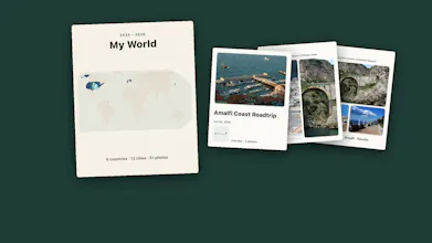
Timeline Visualize turns your camera roll trip photos (using EXIF GPS and timestamps) or Google Maps Timeline JSON exports into animated 3D route flyover videos and interactive scratch maps. No live GPX tracking or manual pin-dropping needed. Reconstruct past road trips, flights, and multi-city journeys in seconds on iOS and Android.




Free Options
Launch tags:User Experience
Launch Team

AWS Startup AdvisorPersonalized AWS guidance that meets you where you’re already building
Promoted
Hey Product Hunt!
I am Mert, the maker of Timeline Visualize.
When Google moved Maps Timeline to local device storage, many of us either lost years of travel history or ended up with a raw JSON export we could not easily visualize. At the same time, whenever I came back from a multi-city trip with hundreds of photos in my camera roll, every route video app required live GPX tracking during the trip or dropping pins by hand one by one.
So I built Timeline Visualize for iOS and Android:
1. Photo-to-Route in one tap: Select existing photos from any past trip and it extracts EXIF GPS coordinates and timestamps to build your route on a 3D globe.
2. Google Maps Timeline JSON Import: Import your local Timeline backup to see years of movement and build a visited countries and cities scratch map.
3. 3D Flyover Video Export: Export vertical or horizontal 3D animated map videos with photo popups at each stop.
You can test the photo-to-route flow and timeline import with the free tier right away. I would love your honest feedback on the 3D camera speed and what export options you want to see next!