
SafeZone Chicago
Free neighborhood safety map with real-time crime data
3 followers
Free neighborhood safety map with real-time crime data
3 followers
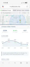
SafeZone is a free interactive safety map for Chicago. Click anywhere on the map to see a safety score (0-100), incident breakdown by type, 5-year crime trends, hourly patterns, restaurant health inspections, and nearest police station. All data comes from the City of Chicago Open Data Portal and updates weekly. Built for anyone moving to, visiting, or living in Chicago who wants to make informed decisions about where they go.


Hey PH!
When I moved to Chicago in 2023, the first advice I got was: "Don't go south. It's dangerous." I took that advice. For three years, I barely set foot in the South Side.
Then I actually looked at the data. Neighborhoods like Beverly, Mount Greenwood, and Hegewisch, all on the South Side, scored far safer than I expected. Some scored higher than North Side neighborhoods people recommend without a second thought. I'd been avoiding a huge part of my own city based on reputation, not reality.
The other thing that frustrated me was apartment hunting. Every time I looked at a new place, I had no idea how to evaluate the area. Ask friends? Everyone has a different opinion. Google it? You get Reddit threads from 2019. Check the city's data portal? Good luck making sense of millions of rows.
So I built SafeZone. Search any Chicago address, get a safety score out of 100 — broken down by violence, property crime, and traffic. Toggle day vs night, weekday vs weekend. No opinions, just numbers.
Last week I showed SafeZone to people who actually live in these neighborhoods. They said the scores closely matched their real experience living there. That was the validation I needed.
It's free, no sign-up, no ads. All data is sourced from official government database, updated weekly.
What city should I build next?
safezone.city