
PeakNav
View mountain paths in 3D
7 followers
View mountain paths in 3D
7 followers
PeakNav, a mobile application designed to immerse users in the breathtaking world of mountains and paths in stunning 3D detail. Navigate through immersive 3D landscapes but also capture memorable moments and share them with friends.
This is the 2nd launch from PeakNav. View more

PeakNav
Launching today
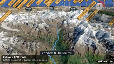
PeakNav drapes satellite imagery, OpenStreetMap trails and place names over a real elevation model of the whole planet. Fly over any range, tap a summit to orbit it, point your phone at the horizon to name the peaks in front of you, or open a photo and have it tagged with the mountains it shows. GPX tracks replay in 3D with their height profile; ski runs and lifts are painted on the slopes. Free, open source (GPL v3), works offline, on Android, iOS, Windows, macOS and Linux.


Free
Launch Team

Render: Get up to $100K in startup creditsThe fastest way to deploy and scale apps and agents
Promoted

Hi Product Hunt! PeakNav is a one-person project, and this is its second time here.
PeakNav began as a way to answer "what's that mountain?" when there is no signal. It renders the terrain of the whole planet in 3D on your phone or desktop, from open elevation data and OpenStreetMap, and once an area is downloaded everything works offline.
What's new since the first launch: photo tagging (open a picture, PeakNav matches its skyline to the terrain and names the summits in it), GPX tracks replayed in 3D with a height profile, a walking route to any point you tap, ski runs and lifts drawn on the slopes, a pane about any peak you tap, and fifteen more languages. It is one codebase (Java + libGDX) running on Android, iOS, Windows, macOS and Linux, open source under GPL v3, with a Python package to read elevations or drive the renderer from a script.
I'd love to hear which mountains you try it on, and anything that looks wrong from where you stand.