Maps for Excel

Maps for Excel

geocoding heatmap boundaries dicrections streetview placeid

7 followers

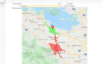
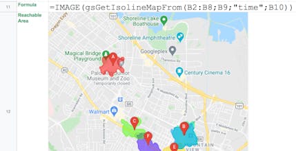
Bring mapping capabilities and geocoding to Microsoft Excel: insert heatmap, administrative boundaries, shapes, place photos and street views, download GeoJSON and KML, get address components, find places with details, build routes, show isolines.
Maps for Excel gallery image
Free Options
Launch tags:SpreadsheetsMaps
Launch Team / Built With
AppSignal
AppSignal
Get the APM insights you need without enterprise price tags.
Promoted

What do you think? …

Aleksei Lukash
Bring mapping capabilities and geocoding to Microsoft Excel: insert static maps with heatmap, administrative boundaries, shapes and geo-objects, place photos and street views, download GeoJSON and KML, get address components, find places with details, build routes, show isolines and have some other geocoding functions in your spreadsheet. In addition to numerous mapping services, there are powerful utilities for working with spreadsheet images!
Karen Anderson
This looks like a super handy tool for Excel! Haven't tried it yet, but I love how it integrates mapping and geocoding features. Definitely something I could use for my projects. Congrats on the launch!