GPXZ Elevation API

GPXZ Elevation API

A simple API for high-quality elevation data.

0 followers

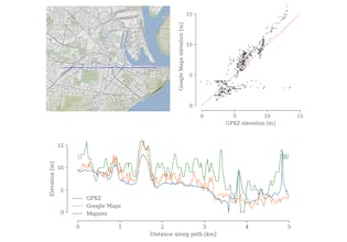
The GPXZ elevation dataset seamlessly merges high quality open data, from global bathymetry to 1m lidar. Our API lets you make low-latency point queries, high-throughput batch lookups, and has a drop-in endpoint compatible with the Google Maps Elevation API.
GPXZ Elevation API gallery image
Free Options
Launch tags:APISaaS
Launch Team
Vy - Cross platform AI agent
AI agent that uses your computer, cross platform, no APIs
Promoted

What do you think? …

Andrew Nisbet
Hi Product Hunt! GPXZ is an API for elevation point queries. These APIs are used for things like flight planning, flood simulation, elevation profile visualisation, and weather forecast localisation. Google Maps is the name brand elevation API but it's expensive, you are restricted in how you use the data, they decrease accuracy for batch queries, and their dataset is being left behind by all the amazing open data sources released in the last few years. You can self-host an API serving open data (I also develop https://github.com/ajnisbet/open... which helps you do this) but elevation data comes in different formats and quality levels which are non-trivial to merge without artefacts, and the datasets are too large for a typical cloud workflow. So I built the 15 TB GPXZ dataset, which carefully merges open lidar and satellite sources covering the whole globe. The idea is that with a single dataset you can get the best-possible data in your area of interest. I have a few freelance customers for various elevation-related projects that have been extremely helpful in validating this idea. Happy to answer any questions about elevation data or building geospatial APIs!