
Aurora Go
Aurora forecast tonight
5 followers
Aurora forecast tonight
5 followers
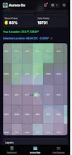
View real-time aurora probability on an interactive map. Toggle the cloud layer to see if skies are clear, check recent community sightings, and use live webcams to confirm conditions before heading out. Set your location and preferred Kp threshold to receive push alerts only when aurora conditions match your spot. All metrics come with short, plain-English explanations—no space weather knowledge required.


This is a fantastic consolidation of tools into one map. The focus on plain-English explanations for complex data is exactly what beginners need.
A practical question for planning: Does the app account for local light pollution in its probability forecasts? A high Kp index with clear skies in a city might still mean no visible aurora.
@olajiggy321
Great point!
You’re absolutely right.
Right now, the app doesn’t yet account for local light pollution in its forecasts. As you mentioned, even with strong aurora activity and clear skies, city light pollution can still prevent visible sightings.
This is a really good idea, and I plan to incorporate global light pollution data and display it on the map within the next few weeks. The goal is to help users assess real-world visibility, not just aurora strength.
Thanks for the thoughtful feedback.
It’s exactly the kind of input that helps shape the roadmap.
@secretjuju
Thanks, SeungBo. Really glad the light pollution idea resonated and is going on the roadmap—that will make a huge difference for urban users.
That focus on real-world usability (beyond raw data) gave me a small, practical idea on how to communicate the app's unique value more clearly to attract your first users. Something you could try on your own.
Best way to share it with you
Hey @olajiggy321
Just shipped it! 🎉
Added a Light Pollution layer using NASA VIIRS satellite nighttime imagery. You can
now see city lights on the map and find dark sky spots for better aurora viewing.
Thanks again for the great suggestion. If you have any other ideas, feel free to share!