
Launched this week

Albatross by Terrabit
One platform to order, track & share satellite imagery
2 followers
One platform to order, track & share satellite imagery
2 followers
Albatross is a unified platform for satellite imagery procurement. Search archives, task new captures, and track deliveries from one dashboard. Query your entire imagery library spatially, view data in-browser, and collaborate on digitisation with ML-assisted tools. No more operational headaches.


Hey Product Hunt! 👋 I'm Zac, Principal Software Engineer at Terrabit with over 5 years in the geospatial industry. Our team brings 25+ years of collective experience in satellite imagery, and we're excited to launch Albatross.
The problem? Satellite imagery procurement is a mess. Orders disappear into isolated portals with zero visibility on delivery. Data randomly appears weeks later. Sharing terabytes across teams means endless file transfers, confusion, and requiring specialist GIS software just to view it. Geospatial teams become bottlenecks because end users can't order directly. And digitising imagery? A task that should take minutes ends up consuming hours.
We built Albatross because we lived these pain points alongside our clients in mining, energy, infrastructure, government and environmental sectors.
Albatross brings the entire satellite imagery workflow into one platform:
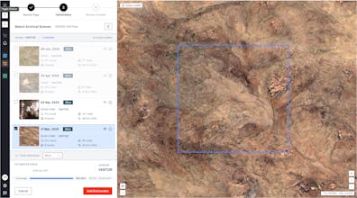
→ 🛰️ Unified ordering - Search archives and task new captures across vendors. End users order directly without the bottleneck with appropriate manager approval pipelines.
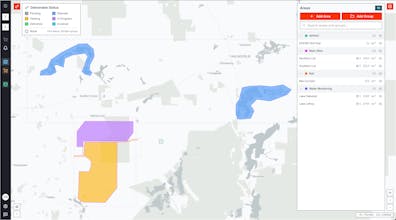
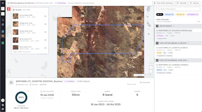
→ 📍 Full transparency - Track every order from request to delivery and view imagery directly in-browser. No GIS software required.
→ 📂 Built-in data catalog - Spatially query terabytes of imagery across vendors and years of time-series data in seconds.
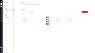
→ 👥 Team governance - Permissions, budgets, and workspaces that scale across departments and projects.
→ 🤖 ML-assisted digitisation (in development) - Collaborative feature extraction that turns hours into minutes.
We're already helping some of the largest companies in mining, government, energy and infrastructure simplify their geospatial operations.
No hefty platform fees. You pay for the data itself with minimal annual commitments to access the portal.
We'd love to show you what Albatross can do for your team and hear your feedback. Book a demo at terrabit.com.au and see how we can simplify your geospatial workflows. 🙏